
File:2010 Chile earthquake epicenter.png
此为最大尺寸。
2010_Chile_earthquake_epicenter.png (269 × 589像素,文件大小:112 KB,MIME类型:image/png)
| 描述 |
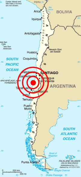
Deutsch: Karte von Chile aus dem CIA World Factbook mit dem Epizentrum des Erdbebens 2010 Chile
Español: Mapa de Chile de la CIA World Factbook, con el epicentro del terremoto de Chile 2010
Français : Carte du Chili de la CIA World Factbook avec l'épicentre du tremblement de terre du Chili 2010
Português: Mapa do Chile da CIA World Factbook, com o epicentro do terremoto do Chile em 2010 |
| 日期 | (original); 2010-02-27 (This image) |
| 来源 | Originally from Central Intelligence Agency's World Factbook. Location of epicenter from BBC |
| 作者 | Central Intelligence Agency's World Factbook |
| 授权 (二次使用本文件) |
PD-USGOV-CIA-WF. |
许可协议
|
|
 |
| 註解 | 該圖片含有註解:在維基媒體共享資源上查看註解 |
文件历史
点击某个日期/时间查看对应时刻的文件。
| 日期/时间 | 缩略图 | 大小 | 用户 | 备注 | |
|---|---|---|---|---|---|
| 当前 | 2010年2月27日 (六) 13:45 | | 269 × 589(112 KB) | Cargoking | {{Information |Description=Map of en:Chile from [http://www.lib.utexas.edu/maps/cia02/chile_sm02.gif CIA World Factbook] with the epicenter of 2010 Chile earthquake marked. |Source=Originally from Central Intelligence Agen |
文件用途
以下页面使用本文件:
全域文件用途
以下其他wiki使用此文件:
- be.wikipedia.org上的用途
- bg.wikipedia.org上的用途
- ckb.wikipedia.org上的用途
- cy.wikipedia.org上的用途
- da.wikipedia.org上的用途
- en.wikipedia.org上的用途
- en.wikinews.org上的用途
- eo.wikipedia.org上的用途
- es.wikinews.org上的用途
- et.wikipedia.org上的用途
- fa.wikipedia.org上的用途
- fi.wikipedia.org上的用途
- fr.wikinews.org上的用途
- ja.wikipedia.org上的用途
- ka.wikipedia.org上的用途
- lt.wikipedia.org上的用途
- ml.wikipedia.org上的用途
- ms.wikipedia.org上的用途
- no.wikinews.org上的用途
- pt.wikinews.org上的用途
- ro.wikipedia.org上的用途
- ro.wikinews.org上的用途
- ru.wikipedia.org上的用途
- ru.wikinews.org上的用途
- sh.wikipedia.org上的用途
- simple.wikipedia.org上的用途
- sq.wikipedia.org上的用途
- sr.wikipedia.org上的用途
- sv.wikipedia.org上的用途
- ta.wikinews.org上的用途
- th.wikipedia.org上的用途
- tr.wikipedia.org上的用途
- uk.wikinews.org上的用途
- vi.wikipedia.org上的用途
- www.wikidata.org上的用途